Land Assessment
Over six decades, the South Florida Water Management District has acquired nearly 1.5 million acres of land within its 16-county jurisdiction to support flood control infrastructure, protect water resources and restore impaired ecosystems. As part of a broad effort to maximize its resources to meet mission-critical responsibilities, the District is conducting a comprehensive land assessment to ensure that each parcel is being put to its most effective use.
Results of First Phase and Next Steps Completed in September 2013, the first phase of the SFWMD land assessment was a review of fee-owned lands – approximately 750,000 acres in which the agency has full or shared ownership rights.
As a result of the assessment process, some properties were recommended for potential exchange or surplus. Following further evaluation by SFWMD staff, final recommendations on exchange or surplus of these lands are being presented to the Governing Board throughout the year.
For more information, see:
Land Assessment Materials by Region
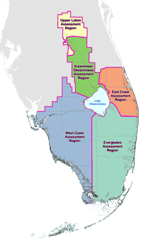
For the first phase of the land assessment process, the 16-county District was divided into five geographic regions. Posted below for each region are detailed land portfolios, summaries of comments from the public and SFWMD subject matter experts and staff recommendations.

* NOTE: Due to a variety of assessment challenges, the Munger Tract (Upper Lakes), Pal-Mar Area (East Coast) and Bird Drive Basin (Everglades) will be analyzed separately from other SFWMD lands in their respective regions. Learn more »
Objectives and Evaluation Criteria
The first phase of the land assessment process thoroughly analyzed each parcel of SFWMD fee-owned land to determine how its current use contributes to the agency's core mission of balancing and improving flood control, water supply, water quality and natural systems. Staff recommended that land uses remain in place for parcels that were determined to contribute fully to the core mission. To provide the most benefit to taxpayers, lands that were determined to not directly support the core mission were considered for alternative uses or recommended to the SFWMD Governing Board for possible surplus.
The District utilized a variety of criteria to evaluate its fee-owned lands, including:
- Analyzing statewide and SFWMD-specific geographic information system (GIS) mapping layers to identify each parcel's environmental value and its value related to water resource management
- Examining the intended uses of the parcels when they were acquired
- Soliciting input from SFWMD subject matter experts with direct knowledge of individual lands
- Receiving feedback and recommendations from stakeholders, nearby landowners, local governments and members of the public
As part of a commitment to transparency and public involvement, the public could review detailed regional land portfolios and submit comments on specific properties on this web page. Regional workshops were held to gather further public input.
